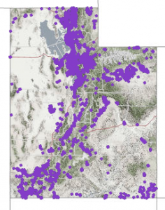
Our December 2017 Map of the Month highlights Utah’s statewide “Address Point” map layer — a vital, statewide information asset. The Address Point map layer is a collection of all...
Last updated: December 21, 2017
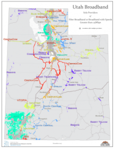
November 2017 Map of the Month: Sole Provider Areas
There are still quite a few areas in Utah that have a sole provider of high speed broadband service. This is more likely in rural communities and remote areas where...
Last updated: November 22, 2017

September 2017 Map of the Month: ‘Extra Coverage’ in the FCC Form 477 Broadband Maps
Our September map of the month revisits a topic that we explored in October of 2014 — how Utah’s broadband coverage is overrepresented in the Federal Communications Commission’s (FCC) Form...
Last updated: September 21, 2017
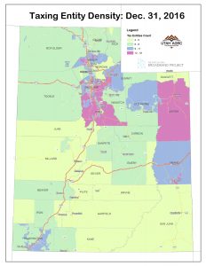
March 2017 Map of the Month: Utah’s Local, Special Service, and Redevelopment Districts
Local and special service districts are an important user constituency for broadband services. In addition to broadband use at district headquarters, many are also dependent on broadband for field and...
Last updated: March 14, 2017
February 2016 MOTM: States’ FirstNet Coverage Objective Maps Released in RFP
The federal-level First Responder Network Authority (FirstNet) issued its Request for Proposals (RFP) for the deployment of the nationwide public safety broadband network on January 13....
Last updated: February 4, 2016
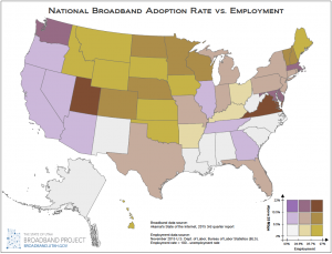
January 2016 Map of the Month: Broadband Access & Employment
Happy New Year and welcome to the first 2016 installment of the Broadband Outreach Center’s Map of the Month series. This month we’ve mashed up two state-by-state level datasets that,...
Last updated: January 21, 2016
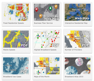
December 2015 Map of the Month: New Online Map Gallery
Since its inception in April 2012, over 40 maps have been published in the Utah Broadband Outreach Center‘s Map of the Month series. And, that’s in addition to the BOC’s...
Last updated: December 23, 2015

Jan 15 Map of the Month: Visualizing Broadband Drive Tests
The Utah Broadband Project contracted with Isotrope, LLC to perform a mobile broadband drive test along over 6,000 miles of Utah’s highways and major roads. This dataset was used for...
Last updated: January 24, 2015
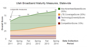
November 2014 “Map” of the Month: Maturity Scores Highlight Impressive Broadband Deployment Success
One of the important objectives of the Utah Broadband Project (UBP) has been to definitively portray Utah’s Broadband landscape. Gone are the days, thankfully, when discussions around broadband policy couldn’t get off...
Last updated: December 1, 2014
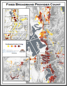
February 2014 Map of the Month: Number of Fixed Broadband Providers per Block
This month’s installment in our Map of the Month series looks at the number of broadband providers capable of providing a ‘fixed’ broadband connection at a defined advertised speed threshold...
Last updated: February 21, 2014