Utah received dedicated funding as part of the NTIA’s State Broadband Initiative to work in partnership with local government to build a statewide address point dataset map layer. In June...
Last updated: December 4, 2013
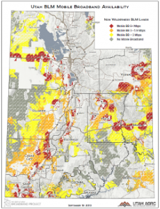
Sept 2013 Map of the Month: Mobile BB on USFS and BLM Land
Over 66% of Utah’s lands are owned and administered by the federal government and its agencies. Among the 50 states, only Nevada has a higher percentage. States with a large...
Last updated: September 19, 2013
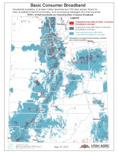
May 2013 Map of the Month: Speed-based Use Cases and Populated Areas
The Utah Broadband Project’s May 2013 map of the month displays Utah’s populated areas with broadband coverage areas for 3 different levels of service. The data sources are residential and mobile...
Last updated: May 20, 2013