
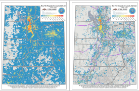
Our September map of the month revisits a topic that we explored in October of 2014 — how Utah’s broadband coverage is overrepresented in the Federal Communications Commission’s (FCC) Form...
Last updated: September 21, 2017
April 2017 Map of the Month: ‘Where For’ locate.utah.gov
In May of 2015, the Broadband Outreach Center first launched the Utah Economic Development map (locate.utah.gov). This web map application allows companies and site selectors to interactively explore Utah from...
Last updated: April 27, 2017
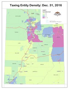
March 2017 Map of the Month: Utah’s Local, Special Service, and Redevelopment Districts
Local and special service districts are an important user constituency for broadband services. In addition to broadband use at district headquarters, many are also dependent on broadband for field and...
Last updated: March 14, 2017
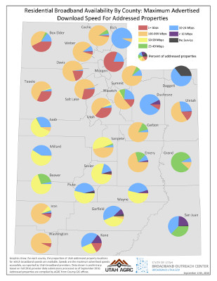
September 2016 Map of the Month: County Broadband Metrics from Address Points
Our July 2016 map featured a statewide map of Utah address points colored by residential-class broadband speed. This month, we’ve used a similar approach to create a graphic that summarizes...
Last updated: September 26, 2016
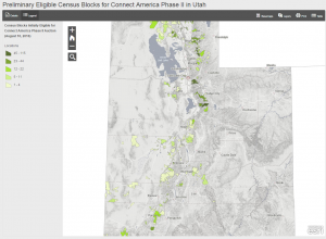
August 2016 Map of the Month: CAF Preliminary Phase II Blocks
On August 10, 2016, The Wireline Competition Bureau at the Federal Communications Commission (FCC) released a preliminary list of census blocks that have been deemed initially eligible for the Connect...
Last updated: August 29, 2016
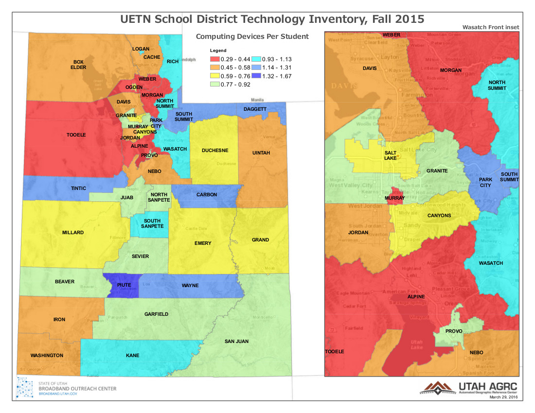
March 2016 Map of the Month: Utah School Technology Study
The March Map of the Month highlights UETN’s Utah School Technology Study. This past Fall (2015), the Utah Education and Telehealth Network (UETN) commissioned a comprehensive, statewide technology inventory across...
Last updated: March 30, 2016
February 2016 MOTM: States’ FirstNet Coverage Objective Maps Released in RFP
The federal-level First Responder Network Authority (FirstNet) issued its Request for Proposals (RFP) for the deployment of the nationwide public safety broadband network on January 13....
Last updated: February 4, 2016
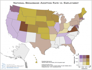
January 2016 Map of the Month: Broadband Access & Employment
Happy New Year and welcome to the first 2016 installment of the Broadband Outreach Center’s Map of the Month series. This month we’ve mashed up two state-by-state level datasets that,...
Last updated: January 21, 2016
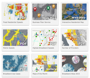
December 2015 Map of the Month: New Online Map Gallery
Since its inception in April 2012, over 40 maps have been published in the Utah Broadband Outreach Center‘s Map of the Month series. And, that’s in addition to the BOC’s...
Last updated: December 23, 2015
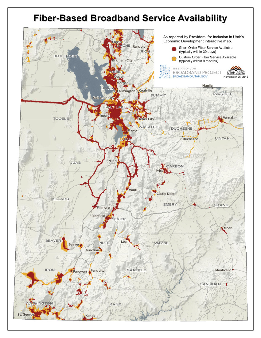
November 2015 Map of the Month: Commercial Fiber Service Availability
The November 2015 Map of the Month shows, at a statewide scale, the current commercial fiber-based broadband service availability reported to the Broadband Outreach Center for inclusion on the locate.utah.gov...
Last updated: November 25, 2015