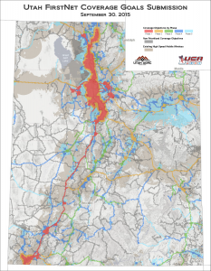
The October 2015 Map of the Month shows Utah’s FirstNet Coverage Goals for the Nationwide Public Safety Broadband Network (NPSBN)....
Last updated: October 30, 2015
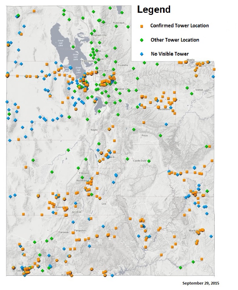
September 2015 Map of the Month: Communication Tower Mapathon
In a recent meeting of the Utah Broadband Advisory Council, members indicated that a statewide map data layer of communication tower sites would present numerous uses. These included fire defense planning...
Last updated: September 30, 2015

Pell Center Advocates State-Level Broadband Policy
The Pell Center for International Relations and Public Policy published an article this month, State-Level Broadband Policy: A Compendium of Resources and Approaches which outlines why broadband policy matters for civic...
Last updated: September 14, 2015

August 2015 Map of the Month: State to State – A Quick Comparison
Utah often ranks high in national (and international) studies on access to fast broadband Internet speeds. Most recently, Utah was ranked 4th in the nation for broadband speeds. This month, our maps...
Last updated: August 18, 2015

July 2015 Map of the Month: Authorized BLM Communication Site Sections
The Bureau of Land Management (BLM) has authority and a formal process to authorize communications sites on land that it owns. Many of Utah’s radio, TV, and broadband delivering antenna...
Last updated: July 23, 2015

June 2015 Map of the Month: Utah Enterprise Zones now on locate.utah.gov
This month the Broadband Outreach Center added Utah Enterprise Zones to the Economic Development map (locate.utah.gov), the Center’s commercial broadband map application. Locate.utah.gov is a tool that helps businesses find...
Last updated: June 18, 2015
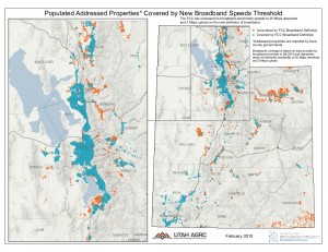
February 2015 Map of the Month: Utah Outperforming On New FCC Broadband Benchmarks
Last month, the Federal Communications Commission (FCC) announced an update to its broadband benchmarks which are now set at 25 Mbps for advertised download speeds and 3 Mbps for upload speeds. Using...
Last updated: February 27, 2015

Jan 15 Map of the Month: Visualizing Broadband Drive Tests
The Utah Broadband Project contracted with Isotrope, LLC to perform a mobile broadband drive test along over 6,000 miles of Utah’s highways and major roads. This dataset was used for...
Last updated: January 24, 2015

December 2014 Map of the Month: Utah’s Changing Broadband Landscape Update
This month, the Utah Broadband Project’s mapping team updated October 2013’s Map of the Month, which mapped the increase in maximum advertised download speeds per populated place over the course...
Last updated: December 16, 2014
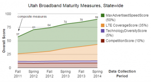
November 2014 “Map” of the Month: Maturity Scores Highlight Impressive Broadband Deployment Success
One of the important objectives of the Utah Broadband Project (UBP) has been to definitively portray Utah’s Broadband landscape. Gone are the days, thankfully, when discussions around broadband policy couldn’t get off...
Last updated: December 1, 2014