
Our August 2014’s Map of the Month discussed and detailed the significant transition and associated data collection changes that the National Broadband Map (NBM) is slated to undergo. The October map of the...
Last updated: October 20, 2014

September 2014 Map of the Month: Utah’s Rural School Classification
Recently, the Federal Communications Commission (FCC) released an Order making reforms to the E-Rate program, which helps provide discounts to schools and libraries in rural areas ensuring that they are...
Last updated: September 25, 2014
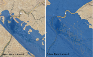
August 2014 Map of the Month: Transition to FCC Data Collection
Changes are coming to the data collection process for broadband availability mapping data. Since 2010, states have collected data from providers, and then submitted a compilation of the data to the...
Last updated: July 23, 2014
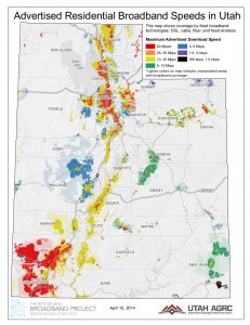
April 2014 Map of the Month: Utah Broadband Landscape at a Glance
Twice a year, the Utah Broadband Project updates the statewide broadband coverage map data. Utah’s latest update was submitted to the Federal Communications Commission (FCC) and the National Telecommunications and...
Last updated: April 17, 2014
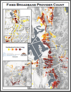
February 2014 Map of the Month: Number of Fixed Broadband Providers per Block
This month’s installment in our Map of the Month series looks at the number of broadband providers capable of providing a ‘fixed’ broadband connection at a defined advertised speed threshold...
Last updated: February 21, 2014

January Map of the Month: Preliminary Mobile Drive Test Results of LTE Service in Utah
After a competitive bid process, the Utah Broadband Project contracted with Isotrope, LLC to conduct a statewide mobile broadband drive test over 6,000 miles of Utah roads in November 2013....
Last updated: January 21, 2014

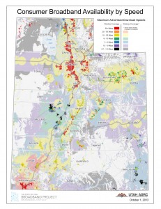
Oct 2013 Map of the Month: Utah’s Changing Broadband Landscape
This month the Project’s mapping team compared how advertised broadband speeds have changed since the beginning of the Utah Broadband Project. The comparison goes from Fall 2010 – Fall 2013....
Last updated: October 16, 2013
Fall 2013 Broadband Data Submission
In preparation for the Fall 2013 Data Submission to the Federal Communications Commission (FCC) and the National Telecommunications and Information Administration (NTIA), the Utah Broadband Project worked with 54 broadband...
Last updated: October 11, 2013
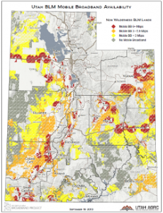
Sept 2013 Map of the Month: Mobile BB on USFS and BLM Land
Over 66% of Utah’s lands are owned and administered by the federal government and its agencies. Among the 50 states, only Nevada has a higher percentage. States with a large...
Last updated: September 19, 2013
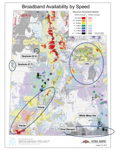
August 2013 Map of the Month: Broadband on Tribal Lands
For August’s Map of the Month, the Utah Broadband Project is sharing maps made for use at the Governor’s Native American Summit, which took place August 14-15, 2013 at Utah...
Last updated: August 26, 2013