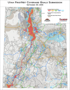
The October 2015 Map of the Month shows Utah’s FirstNet Coverage Goals for the Nationwide Public Safety Broadband Network (NPSBN)....
Last updated: October 30, 2015

July 2015 Map of the Month: Authorized BLM Communication Site Sections
The Bureau of Land Management (BLM) has authority and a formal process to authorize communications sites on land that it owns. Many of Utah’s radio, TV, and broadband delivering antenna...
Last updated: July 23, 2015

March 2015 Map of the Month: LTE Wireless Buildout October 2011- October 2014
Over the past 4 years, the demand for fast mobile broadband (Internet accessed through a portable mobile device) has greatly increased. Fast mobile broadband is critical for communications in public...
Last updated: March 26, 2015

May 2014 Map of the Month: Broadband Availability at Utah’s Tourist Attractions
Summer is upon us, so for the May Map of the Month series, the Project’s mapping team analyzed broadband capabilities at Visitor Centers in Utah’s outdoor recreation areas. In the graphic at right,...
Last updated: May 30, 2014

January Map of the Month: Preliminary Mobile Drive Test Results of LTE Service in Utah
After a competitive bid process, the Utah Broadband Project contracted with Isotrope, LLC to conduct a statewide mobile broadband drive test over 6,000 miles of Utah roads in November 2013....
Last updated: January 21, 2014